GeoShop Online Store | INDOGEOTECH GROUP ( 021-58907790) : : garmin gps authorize dealer : gps garmin, gps trimble, gps magellan, gps spectra, gps geodetic, total station, digital teodolit, automatic level, waterpass, distometer, binocular, kompas
LOKASI : Kota Administrasi Jakarta Barat
Bergabung Selama :
- Garmin gps 76 Basic handeld
Produk atau jasa ini sudah tidak dijual, silakan hubungi perusahaan bersangkutan untuk keterangan lebih lanjut.
Garmin gps 76 Basic handeld
Update Terakhir
:
01 / 12 / 2019
Perhatian !
Perusahaan ini terdaftar sebagai Free Member. Hindari melakukan pembayaran sebelum bertemu penjual atau melihat barang secara langsung. COD (Cash On Delivery) atau bertemu langsung dengan penjual merupakan metode transaksi aman yang kami sarankan.
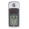
Detail Garmin Gps 76 Basic Handeld
Garmin GPS 76
Use on Land or Water
Part of the mariner-friendly 76-series handheld navigators, the GPS 76 is WAAS-enabled for accuracy to within 3 meters and features a large, crisp display and easy-to-use buttons.
Don't worry about losing this GPS device in the drink. The GPS 76 floats in water, and it's IPX7 waterproof to withstand the accidental dunk or splash in the lake. Whether on water or land, the GPS 76 can save up to 500 of your favorite places in memory and create a straight-line route to your destination.
Store Important Data
The GPS 76 is preloaded with worldwide cities as well as marine navigation aids, including lights, buoys, sound signals and day beacons. If you're into boating, hunting or fishing, you can use the 76's built-in celestial data, which includes tide information, sunrise/sunset times and a hunting and fishing calendar.
GPS 76: Rugged handheld navigation for your land and sea adventures
Physical & Performance:
Unit dimensions, WxHxD: 2.7" x 6.2" x 1.2" (6.9 x 15.7 x 3.0
Display size, WxH: 1.6" x 2.2" (4.1 x 5.6 cm)
Display resolution, WxH: 180 x 240 pixels
Display type: 4 level gray LCD
Weight: 7.7 oz (218 g) with batteries
Battery: 2 AA batteries (not included)
Battery life: 16 hours
Waterproof: yes (IPX7)
Floats: yes
High-sensitivity receiver: no
PC interface: serial
RoHS version available: yes
Maps & Memory:
Basemap: no
Preloaded maps: no
Ability to add maps: accepts points of interest data
Built-in memory: no
Accepts data cards: no
Waypoints/favorites/locations: 500
Routes: 50
Track log: 2,048 points, 10 saved tracks
Features:
Automatic routing (turn by turn routing on roads): no
Electronic compass: no
Barometric altimeter: no
Geocaching mode: no
Outdoor GPS games: no
Hunt/fish calendar: yes
Sun and moon information: yes
Tide tables: yes
Area calculation: yes
Custom POIs (ability to add additional points of interest): no
Unit-to-unit transfer (shares data wirelessly with similar units): no
Picture viewer: no
Tampilkan Lebih Banyak